We needed good internet access to get caught up on email and our blog. After checking out the available campgrounds we settled on the “Hitch ’n Post” in Panguitch, UT as our destination for the day with plans to head to Cedar Break National Monument the next day. The campground was in the town itself so we could walk to the market and, more important, to the liquor store since we are going through cold beer at a breakout speed – I’m having a hard time keeping up with Diane who seemingly has a hollow leg. 😉
Capitol Reef National Park
No drive-by tourism for us this time around. We took it upon ourselves to spend some time walking the trails of the park. Why hike you ask? For one, Diane has really been hitting the potato chips hard and she needs the exercise desperately (what a mean and terrible thing to say! – especially since it’s not true. It’s the salted almonds that are doing her in.) . Secondly, it seems that not many people actually walk on the trails so there are no crowds like you encounter at all the pull-outs for photo opportunities. (Not that I’m crowd-averse or anything like that). Finally, you see things (like Cohab Canyon) that are not even visible from the road.
Moab to Torrey, UT
I tried to capture the incredible scenery that we were riding through on highway 24 today even though it involved a 30 mile section of I-70 which didn’t make Diane very happy, especially with a speed limit of 80mph. Thankfully, traffic on the interstate was light and we were off of it before long. Avoiding the interstate all together would have been a two day detour since Canyonlands National Park extends quite a way south with no easy east-west connection. No epic hikes today, just beautiful landscape.
Canyonlands National Park – Island in the Sky
Being on the road and camping can lead to interesting encounters. During our ‘down day’ on Thursday, while sitting in the community kitchen in the late afternoon using our electronic gear, Diana and Faulk, a couple from Canada joined us at our table because the other tables were taken by a church youth group. We struck up a conversation and chatted amiably about our plans and what they had seen and planned to do. When we ran into them again on late Friday afternoon they shared their itinerary which listed the campgrounds they were staying in. They had done their research – Diana had a “must have clean bathroom” criteria similar to Diane’s – which we leveraged by making note of the campgrounds in Torrey, UT (Capital Reef National Park) and Escalante, CO (Grand Staircase Escalante) since we are planning to visit both places.
Continue reading Canyonlands National Park – Island in the Sky
Hovenweep – Ruins Trail hike
We got through the rainstorm with much less leakage. There were a couple of drops but nothing that wouldn’t allow us to go to sleep. Morning broke with lingering black clouds but no rain.
To Hovenweep National Monument
With the rain fly replacement situation squared away we left South Fork albeit a little later than usual. We had no traffic for the first part into Pagosa Springs which made the winding road through the mountain pass even more enjoyable and was deemed “Diane’s favorite road, so far”. We stayed on US160 all the way to Cortez, CO, winding our way through the river valley and gentle hills (by Colorado standards).
Equipment Failures
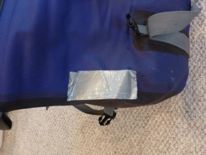
Same waterproof duffle bag, same failure. After my bag failed on the last trip

it was now Diane’s turn to have her exact same model bag fail, also along the ‘welded’ seam. Hers was so bad that only after a couple of times of handling the bag the seam kept separating almost all the way! Not good. Not only is it obviously no longer waterproof but there is the danger of stuff falling out when the seam separates at some place that we didn’t duct tape.
Heading west again and trying to avoid the rain
Even when we don’t have to take down and pack a tent it takes us long in the morning to leave 🙂 (damn, all out of excuses). Then again, we weren’t really in a hurry to get stuck in Denver rush hour traffic so it was around 10:30 when we finally left Mike’s place. Leaving Denver behind us we were heading into uncertain weather with black clouds looming all around us. Since my ‘point&shoot’ camera that hangs on a lanyard around my neck isn’t waterproof it stayed in the tank bag for most of today’s ride.
Continue reading Heading west again and trying to avoid the rain
In Denver for the weekend
During our normal morning routine, while drinking tea and coffee we check the weather forecast for the area we plan to ride to and, unfortunately, it didn’t look good. The weather radar was basically a sea of green – rain everywhere :-(. While a small shower is no big deal, continuous rain is a different matter. It’s not fun to ride in and camping in, even less so. What to do?
How to avoid mountain passes
Since locating a campsite last night took us further east than planned we evaluated ways to get back west. One option was to double back where we came from through Montrose (boring) or take CO-92 to Hotchkiss (Diane vetoed) and then head towards Grand Junction and ultimately the Colorado National Monument. Sidenote: In addition to standard street maps we also have a set of Butler Maps that are motorcycling specific, highlighting all the ‘interesting’ (aka twisty, scenic, long drops to the bottom) roads. Any potential route is always crosschecked against the Butler map. Diane is using it in a way I’m sure the designers didn’t intend to — she’s looking for routes to avoid rather than take :-).